Banat Watershed Area
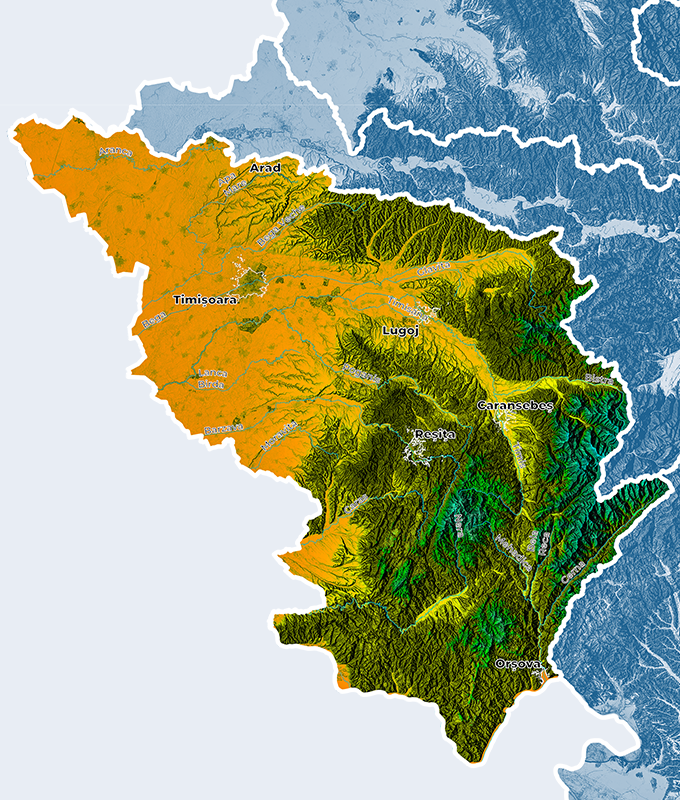
Banat Watershed Area is located to the South-Western part of the country, bordering to the North on Mures River Basin, to the West on Serbia, to the East on Mures River Basin and Jiu Watershed Area, to the South on the Danube.


Where is it located?
The total area of Banat Watershed is of 18,312.20 sq. km, representing a ratio of 7.68% from the county area. The hydrographic network includes 389 surveyed water courses (of which 19 have areas of less than 10 sq. km), with a total length of 6,700 km and an average density of 0.36 km/sq. km. On the Romanian territory, Banat watershed area includes the sub-basins: Aranca with 9 coded tributaries, Timis with 149 coded tributaries, Bega with 79 coded tributaries, Caras with 30 coded tributaries, Nera with 35 coded tributaries, Cerna with 41 coded tributaries and 40 tributaries of the Danube.
Relief of the river basin
Maximum altitudes are to be found in Godeanu Mountains (2,229 m), on the watershed between Cerna and Mures River Basins. Cernei Mountains, with the maximum altitude in Banat Watershed area of 1,928 meters (Dobrii Summit), features a high elevation level, a relief energy of 400-700 meters generating a rapid flow of the rivers. Mehedinti Mountains guard the Eastern part of Cerna River Basin and have the maximum altitude in Banat Watershed Area of 1,229 meters (Coltul Pietrei) and of 1,105 meters (Domogled). Mehedinti Mountains continue with Mehedinti Plateau, a piedmont with lower altitudes. To the Central and Southern part of Banat Watershed Area there are Banatului Mountains, which, though with a lower altitude (maximum altitude of 1446 m), have a significant input to the area hydrographic network. Semenicului Mountains are characterized by a gentle landscape, and the landscape fragmentation varies between 600-700 m. Aninei Mountains, stretching to the South-West of Semenic Mountains are a lower elevation, with the maximum altitude in the basin of 1,160 m (Leordis Summit). To the North-West of Aninei Mountains, there are Dognecei Mountains (the maximum attitude of 617 m in Cula Armenisului Summit). Almajului Mountains (1,224 m in Svinecea Mare Summit) and Locvei Mountains (Corhanu Mare Summit of 735 m) complements the alpine landscape of Banat. Poiana Rusca Mountains (the maximum altitude in Pades Summit -1,374 m), with average altitudes of 700 m, stretch to the North of the tectonic corridor of Bistra. The landscape fragmentation varies between 500-700 m.
Hilly peaks are separated by many intra-mountain depressions: Almaj, Ezeris, Mehadica and by tectonic corridors: Timis-Cerna Corridor, Bistra Corridor. Hills (Lipovei Hills, Sacos-Zagujeni Hills, Tirolului Hills, Oravitei Hills, Bozoviciului Hills) have a relatively limited distribution across river basins in Banat watershed area. As an extension of the mountains and with decreasing altitudes from East to West, Banat piedmonts have altitudes ranging between 170 and 800 m, and the landscape fragmentation is between 50-300 m.
Banatului Plain covers approximately 50% of the area of Banat watershed, being a low-lying plain (minimum altitude of 77 m in the border area), which, in its center, up to the arrangement of Timis-Bega interfluve, was a large marshy area. The relief of the plain sector crossed by Banat river has certain peculiarities, such as progressive elevation decrease to the East-West, each of these steps representing stages of water stagnation from the withdrawing Panonic Lake. Between the localities Bazias and Gura Vaii, there is a distinct geomorphological unit, the Danube Gorge, the most spectacular European gorge, with a total length of 134 km.
The land use in Banat watershed area is influenced by physical and geographical conditions, as well as by anthropic factors, and it has the following distribution: 28.25% forests, 61.37 % agricultural area, 3.49 % area occupied by water and wetlands, 6.89% constructions.
Climate of the river basin
Total water resources
The total surface water resources in Banat watershed area amount to approx. 3380 mil cubic meters/year, of which usable resources are of about 39.2 mil m3/year. They represent around 12% of the total resources and are mainly formed by the rivers Timis, Bega, Barzava, Caras, Nera, Cerna and their tributaries. In Banat watershed area, there are 9 major reservoirs (having an area of more than 0.5 sq. km), with a complex use and totaling a useful volume of 290 mil. cubic meters.
Aranca River Basin
Bega River Basin
Timis River Basin
Caras River Basin
Nera River Basin
Cerna River Basin
Description of existing flood protection works
As major flood protection works in Banat watershed area there are 29 non-permanent reservoirs, totaling a volume intended for flood alleviation of 211 mil. cubic meters, 1,118 km of dikes, 1,037 km of riverbed regularizations and 150 km bank defenses. Reservoirs with a complex use are foreseen with a flood alleviation volume totaling around 69,6 mil. cubic meters.
On the territory of Banat watershed area, 8 dams of category A and B, respectively 55 dams of category C and D are operational.

Flood records
In the 21st century, one should note the extreme events occurred in 2000, 2005, 2006 and respectively in 2010. In 1966, there were floods across the entire Banat watershed area, ending with the breach of the defense dike on Timiṣ river, left bank, close to the locality of Gad. As a known cause of these floods was the large quantity of precipitations recorded across the entire area. This exceptional flood generated peak discharges of 1,100 cubic meters/s in Lugoj and of 1,416 cubic meters /s in Sag.
Contact Banat RBA
Address: B-dul Mihai Viteazul nr. 32, Timisoara
Central office phone: 0256 491848; 0256 491 843; 0256 491849
Management Secretary’s Office: 0256 492097
Fax: 0256 491798
E-mail: dispecer@dab.rowater.ro
 Weather Warnings
