Crisuri Watershed Area
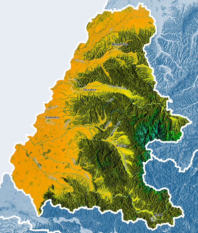
Crisuri Watershed has an area of 14,860 km2, representing around 6.3% of the country territory. Crisuri Basin is situated to the Western part of Romania and is located between 47°06′ and 47°47′ latitude North and 20°04′ and 23°09′ longitude East.


Where is it located?
Relief of the river basin
Climate of the river basin
In climate terms, Crisuri watershed area has a temperate continental climate, of Pannonian type, featuring an interference of influences such as Mediterranean, Baltic and continental.
For this area, we mention the following characteristics of climate factors:
- average annual precipitations have values of up to 1600 mm in the alpine region, of 650 – 800 mm in the hilly area and of 550 – 600 mm in the plain area;
- the average multiannual temperature varies between 4 0C in the alpine region (in Stana de Vale) and over 10 0C in the plain area (in Oradea, Salonta, Chisineu Cris);
- the evapotranspiration is maximum during the warm season. The potential evaporation reaches below 600 mm in the hilly area and around the value of 650 mm in the plain area, and in the alpine region it reaches 450 mm.
Total water resources
Crisuri watershed area includes the waters of a surveyed hydrographic network totaling 365 surveyed water courses and 5785 km, representing 7.3% of the total length of the surveyed network in the country.
The main river in Crisuri watershed area is considered to be Crisul Alb due to its maximum length from its source. It converges on the Hungarian territory with Crisul Negru, forming Crisul Dublu. It collects a series of plain streams in Romania, on Crisul Negru – Crisul Repede interfluve, such as: Culiserul, Barmodul and Ghepesul. Also Crisul Repede flows downstream into Crisul Dublu, after receiving Barcau with Ier.
Crisul Alb River Basin
Crisul Negru River Basin
Crisul Repede River Basin
Barcau River Basin
Ierul River Basin
Ierul / Eriul is 100 km on the Romanian territory, and the catchment area is of 1392 km2 and it collects 11 tributaries.

In Crisuri watershed area there are 9 important reservoirs, with a complex use and two fresh water natural lakes totaling a volume of 1.95 mil. cubic meters and an area of 51 ha: Ghioroc Lake (48 ha – 1.92 mil. cubic meters) which is an excavation lake and Ponoare Lake (3 ha – 0.03 mil. cubic meters) which has a karstic nature.
The surface water resource of Crisuri watershed area, from inland rivers, is of 2937.4 mil.m3, and the underground water resource is of 788.4 mil.m3.
Description of existing flood protection works
For supplying water to certain uses (water supply, irrigation, fishery), as well as for collecting high waters from interfluves etc., 27 adductions and diversions were executed.
Existing flood protection works operational across the entire Crisuri watershed area consists in river regularizations, embankments, bank reinforcements, as well as permanent, non-permanent reservoirs or polders. Such works ensure the flood protection of a total area of approx. 264,000 ha, of around 59.000 households, of 157 industrial objectives, around 174 km of railways, around 1360 km of roads etc. Among the main localities benefiting from protection works, we mention: Marghita, Oradea, Alesd, Huedin, Vascău, Stei, Beius, Brad, Sebis, Ineu, Chisineu – Cris etc.

Flood records
During the spring of 1970, there were serious floods, with significant water discharges being reports almost on all major rivers in Romania. The trigger of the floods from May – June 1970 was a regime of heavy, torrential rains. Besides, the entire period 1 January – 10 May was reach in precipitations, recording double quantities of water by reference to normal multiannual values, which caused the infiltration of no more than 20 – 25% of the rain, the remaining water turning into a runoff. The general feature of floods recorded was its singular nature (single-wave), with sudden increases and slower decreases. The value of damages recoded in Crisuri watershed area was of more than 390 million lei in 1970.
Floods occurred during the period December 1995 – January 1996 were caused by: warming and sudden snowmelt, especially in the alpine and hilly areas, river defrosting, significant rainfalls given an existing frozen soil, unable to allow water infiltration and drainage on slopes towards riverbeds. Floods occurred during two periods, the first one was 23 – 25 December, and the second one – 26 – 27 December and they lasted until the end of the month.
Contact Crisuri RBA
Adress: str. Ion Bogdan nr. 35, Oradea
Phone: +40(259) 442 033; +40(259) 443 892
Fax. +40(259) 444 237; +40(259)442 064
E-mail: dispecerat@dac.rowater.ro; secretariat@dac.rowater.ro
Website: https://crisuri.rowater.ro/
 Weather Warnings
